State Certifier Information
State certifiers, also know as regional certifiers, are responsible for checking and approving applications for course certification. State certifiers (regional certifiers) are Final Signatories. It is their signature that approves the course as USATF certified.
A final signatory may certify a course that they measured. That can lead to some confusion as a certifier in a neighboring state might measure and certify a course in another state. To prevent information voids, it is a courtesy for the final signatory to send a copy of the course certificate to the USATF association in which the course is located.
Once approved, the state certifiers send multiple copies of course certifications to the east or west vice chair who will send them to the national registrar . Here are the details on how to prepare and submit the measurement certificates for the east vice chair.
What do I send to the vice chairman?
You'll need to send the vice chairman two copies of the certification and possibly, a payment. The copies should be two-sided with the certification on one side and the map on the reverse side.
You may want to print a total of six copies: two for the regional certifier, two copies for the measurer, one for the local USATF association and one for you (the state certifier.) One of the two copies for measurer could be printed on high-quality paper.
What is the payment fee and who do I make the check out to?
Send the vice chair a $5 payment for each course certificate. There is no charge for calibration certificate or renewal certificates. Checks should be made payable to the RRTC course (acting) registrar, Gene Newman. (December 13, 2008)
(Note: Vice Chair, Paul Hronjack will keep $1.50 and send $3.50 to the acting course registrar, Gene Newman. The amounts have changed over time. In Feb 2009, Paul kept $1 and sent $4 to the registrar. In October 2008, when Pete Reigel became the registrar, Paul wrote: If I get more cash than I get to keep, I send the excess to Pete. If I get more checks than Pete is due, he sends me what I am owed.)
Who do I mail the certifications to?
In New England, state certifiers should send the paper work to Paul Hronjak. Paul is the RRTC Vice Chairman. His address and telephone number is:
Paul Hronjak
4413 Pinehurst Dr.
Wilson, NC 27896
telephone: 252-237-8218
How do I submit renewals?
Renewed course keeps the original certification number. The expiration date is the earlier of 20 years after the original certification or 2011.
The certification has expired. How do I get that course a valid certification?
If a course certification has expired, then the course certification is treated as though the course certification never existed. That course has to be treated as though it was a new course. The course must be re-measured and assigned a new certification number.
How do I submit certifications for calibration courses?
Submit the certification application like any other course with one exception. There is no payment for submitting the application.
What is Drop?
In order for performances set on a certified course to be eligible for American records, the course must have a net drop of no more than 1/1000 of the race distance (e.g. 10 meters for a 10 km race.) Performances set on a certified courses with a drop that exceeds 1 m/km are still eligible for "best."
The Drop is entered on the Measurement Certificate in meters per kilometer. To calculate, first convert the start and finish elevations to meters and the race distance to kilometers. Then use this formula:
Drop (m/km) = Start elevation (meters) - Finish elevation (meters) / Race distance (kilometers)Note: the Drop may be a positive or negative value. A positive value indicates the course had a net downward slope while a negative value indicates the course has a net upward slope.
What is Separation?
The rules on eligibility for American records make a distinction between courses with start-to-finish separation less than or greater than 30% of the race distance (such as 1.5 km for a 5 km race). The course can be certified either way. However, if the separation exceeds 30%, American records can be accepted only when there isn't a significant tailwind during the race.
The Separation is entered on the Measurement Certificate as a percentage. To calculate, first convert the straight line distance between the start and finish and the race distance to meters. Then use this formula:
Separation % = Straight Line Distance between the start and finish (meters) / Race distance (meters)* 100
Rounding Numbers
Drop and separation calculations are rarely accurate. For example, the elevation is often based on a value from a topographic map or similar and may be accurate within 3 meters. Therefore, the calculated values should be rounded at avoid giving the impression of greater accuracy than is available.
Paul Hronjak suggests rounding should follow the classic rounding method. For example,
2.34 rounds down to 2.3

      2.35 rounds up to 2.3

      2.36 also rounds up to 2.3
The exception may occur when the drop or sepearation values are very close to the record limit. For example, a drop may appear as 0.998 m/km, rather than 1 m/km.
What is the Effective Date?
USATF Rule 240.3b states: Effective date: Certification is effective as of the date that all measurements and necessary adjustments are submitted as evidenced by the postmark (verifiable transmission date), although the actual review and approval of the certification may be at a later date.
This applies whether or not the measurer is a certifier.
If the measurer is not a certifier, and sends data for review to a regional certifier, the effective date is the date when the measurer sends data that the certifier considers acceptable, as indicated by postmark or other verifiable means (e.g., date of email transmission).
When the measurer is a certifier, the effective date is usually the date when the measurer/certifier sends the map and certificate to the next level of review (e.g., Vice Chair), as this is a verifiable transmission date(it should be sent before the race date). In this situation, enter the certificate/map transmission date as both the effective date and the date of the certifier's signature. If timing is tight, meaning that it might not be possible to send the map and certificate before race day, send an email to the Vice Chair when you've completed measurements and adjustments. Then, when writing the certificate, you can use the date of that email as the effective date (and, in this case, the effective date would be earlier than the certifier's signature date).
In all cases, the effective date should not be later than the date of the certifier's signature.
What do I need to add to the maps?
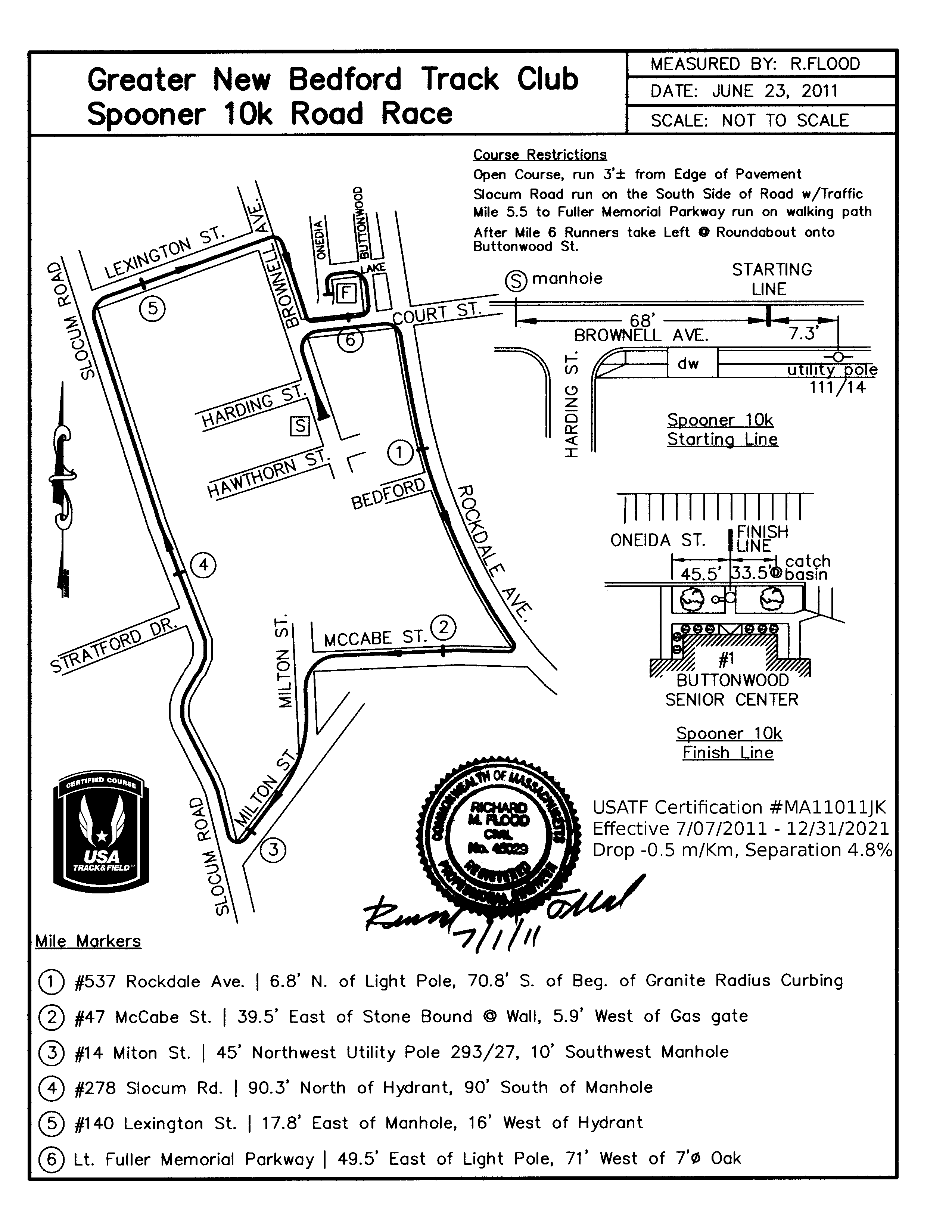
The certifier should add the course certification to the map as well as the dates the certificate is effective. Here's an example.
USATF Certification #MA11019JK

      Effective 9/10/2011 - 12/31/2021

      Drop 0.8 m/Km, Separation 7.7%
Renewals
Some courses may be renewed. The policy is described on the USATF web site. In general, courses measured before 2001 may be renewed for up to 10 years or until December 31, 2011, whichever occurs first. At this point in time, all new renewal certificates will expire on December 31, 2011. Courses measured after 2000 may not be renewed. State certifiers should review the paperwork and issue a new certificate with the original certification number and expiration date of December 31, 2011.
Unlike new course certificates, renewal certificates use the original map and are not re-scanned. According to Stu Riegel anything that's already scanned (1993 and later) generally doesn't get scanned upon renewal. Should the paper version of the renewal certificate include the map on the reverse side? I think the certificate would be easier to use with the map. So far, I have processed just one renewal certificate. I scanned the original map, cleaned the image with GIMP, and added the USATF logo, the expiration date and the courses number.
Accuracy
The two rides must be within a 0.08% of each other. That's the equivalent of 800 parts per million (800 PPM). Compare that to the Total Station which has an accuracy of 5 PPM.
A question came up regarding the accuracy of the calibration rides. The original measurement manual suggested the accuracy of the rides should be within 0.07% of each other. If the count was 3500 for ride 1, then subsequent rides should be within plus or minus 2.45 counts.
Certifying Intermediate Splits
As of 2010 Certified Splits may be included on a single course map. Multiple Certificates are no longer necessary. Here's the process as outlined by Gene in September 2010.
- Issue one certificate with the split's drop/separation displayed on the Certificate as well as on the map(see BB for an example of a Certificate).
- The Registrar will indicate there are certified splits in the Course Name (i.e. Joe’s Half Marathon & Certified Splits, hence the Records people could find the Certified splits information by printing out the map.
Can I use color on my map?
You can use color for the online map. That map must still be able to be printed clearly on a black & white printer.
Submitting an electronic map
Maps may be submitted to the national registrar electronically since 2007. As of March 2012, the process is to send the electronic map and certificate to Gene Newman and one paper copy of the map and certificate to Paul Hronjak. The, electronic map will need to meet the following format specifications:
- PNG format
- 300 x 300 pixels/inch
- Canvas size of 2550 x 3300 dots/inch (8.5" x 11", or 216mm x 280mm, or 51:66 ratio; 0.77)
- 256 colors or less
- not larger than 400 kilobytes
Gene prefers PayPal. Therefore, after sending the electronic maps to Gene, create a personal PayPal payment of $3.50 per course to Gene's email address (xnjnowaz AT gmail.com.) Write a check for $1.50 per course, payable to Paul Hronjak, and include with the paper map.
I recommend a minimum of a 100 pixel white border along the outer edges of the map. The remaining area of the map could be surrounded by a black border. See MA11011JK for an example.
At 300 DPI the 100 pixel border translates to 1/3" (approx. 11/32"). The inside portion of a course map should not be larger than 2350 x 3100 pixels (7.833" x 10.333" or 7-27/32" x 10-21/64" or 199mm x 262mm.) If it's larger, I may need to scale it down.
Finally, you will need to email the electronic map to Pete Riegel. Pete will take the electronic version but says they are "mild pain to do this." Contact Pete before emailing him any files larger than 200K.
Abbreviations
Abbreviations for most units of measurements for use small letters and periods. The few exceptions that use capital letters are noted below. Temperature abbreviations use capitals because they come from proper nouns.
Abbreviations for metric units, including temperatures (Kelvin or Celsius), do not end with periods.
| Abbreviation | Unit of Measurement |
|---|---|
| C | Celsius, Centigrade |
| cm | centimeter |
| F., F | Fahrenheit |
| ft. | foot |
| in. | inch |
| K | Kelvin |
| km | kilometer |
| m | meter |
| mi. | mile |
| mm | millimeter |
| n.m. | nautical miles |
| yd. | yard |
What should I look for when reviewing an application?
There are some items that come up frequently. Here's a short checklist for the map:
| Is the northing arrow present? | |
| Is the course name present? | |
| Is the distance present? | |
| Is the name of the city and state present? | |
| Does the map include a detail sketch of start and finish. Does the detail sketch include text with descriptions? | |
| Is the measurement date present? | |
| Is the measurer's name present? | |
| Are the mile splits clearly labeled? | |
| Are there any discrepancies between application and map? (e.g. cal course is 1099.809 feet yet map says 1100 feet between PK nails.) | |
| Are there any photos on the map? (as of December 2008, photos are no longer accepted) | |
| Is there good contrast on the map? (Maps that are too light or too gray do not copy or scan well.) | |
| Are there wide margins on the map? (If the margins are too narrow, the map may need to be resized so the image is not lost on the edge.) For scanning, Gene recommends a minimum of 3/8" and prefers 1/2". |
Check the Measurement Certificate.
Mistakes happen. With some planning, you can avoid send a certificate with errors. Here are some items that come up frequently while preparing a certificate:
| Is the address complete? Is the phone number complete? | |
| Does the certificate include the race date? | |
| Did the measurer selected the better ride as the final measurement? The measurer should select the ride that produced the shortest measurement. | |
|
Does the map include the USATF measurement logo? This logo is 100 x 130 pixels. (logo-certified-course-mono_tn.png) Click here for a larger image 511 x662. |
|
Does the map include the certificate number. Add text similar to this below the logo:USATF Certification #MA11019JK |
USATF-NE Online Preparation
In addition to preparing the course certificates for the national registrar, I have been preparing and posting the course certificates to the local USATF New England web site (www.usatfne.org/measurement/). Each course certificate is posted to the web site as a single PDF document containing two pages. The first page contains the certificate and the second page contains the course map. Here are a few notes on creating the PDF document.
The first page is already in a PDF format. The PDF form that allows me to enter values like CourseName, Distance, State, City, configuration, etc. To use, copy the certificate.pdf template file, rename it to the course number (ie. MA09001JK.pdf), and open it in Adobe Acrobat Pro. Then, fill in the form with the course data.
Next, add the map to the PDF file. The map may be in PNG, PDF or other image format. Open the page thumbnails located on the left side of the screen. Right mouse-click on the thumbnail of the first page and select insert page. That will open a dialog box prompting for the location of the map file. Press OK. The PDF will convert the map file to a PDF and insert it as page two. Save the PDF.
At this stage the PDF file is still editable. You can flatten the PDF or add security restrictions. If you flatten the PDF, then you can no longer edit any of the fields on the form on the first page. I use the security feature. I set the security to allow all users to print in high quality and extract/copy contents. The owner's password is required to make changes to the document, adding comments, for access to the fill-in fields or assembling the document. File and save the PDF file.
If the size of the file seems large, compress or optimize the PDF file using Adobe Acrobat Pro's built in features.
The map page takes some effort to create. I use the open source GIMP application (GNU Image Manipulation Program) for image editing. I will add the new USATF Certified Course logo to the map page as well as the certification number, effective date, drop and separation values. But first, the map needs to be converted into a digital format that I can open with GIMP.
PNG files may be opened directly in GIMP. PDF files may also be imported into GIMP. When importing the PDF file, set the width to 2550 pixels, the height to 3300 pixels and the resolution to 300 pixels/inch.
If the measurer sent a paper copy of the map, then scan the map as a black and white image at 300 DPI. Save as a TIFF or PNG file and open in GIMP. Use GIMP's eraser tool to remove any scan lines along paper creases.
If necessary, use GIMP's Scale Image tool to set the image width to 2550 pizels, height to 3300 pixels, X and Y resolution to 300 pixels/inch. The image size may not fit 2550 x 3300 perfectly. If the image is size is close, click the chain icon so it displays a broken chain. Reset the size. The image will distort. If the distortion is too noticeable, change the canvas size before scaling the image.
[...to be continued...]
